Community Corner
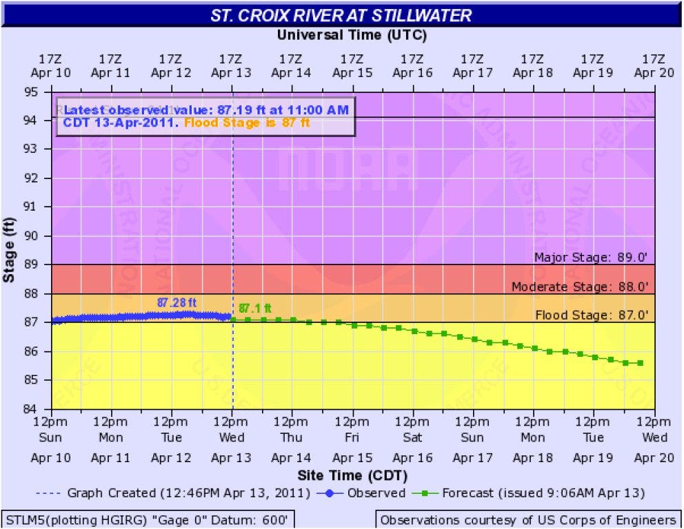
St. Croix River Flood Level at 687.19 Feet
The St. Croix River appears to have crested at 687.28 feet on Tuesday night. See a live video stream of the flood in Hudson at http://patch.com/buTux.
Editor's note: This is no longer the most recent post.
----
As of 11 a.m. on Wednesday, April 13, 2011, the St. Croix River water level was at 687.19 feet and receding in Stillwater, MN. The river appears to have crested Tuesday night at 687.28 feet, just short of the ninth-highest crest recorded.
Find out what's happening in Hudsonwith free, real-time updates from Patch.
A live video stream of the flood at First and Buckeye streets in Hudson is available at http://patch.com/buTux.
The latest forecasts predict the river to continue to recede with waters falling below flood stage (687 feet) by Friday. If forecasts hold true, the river could recede below 686.2 feet on Monday and allow workers to reopen the Stillwater Lift Bridge.
Find out what's happening in Hudsonwith free, real-time updates from Patch.
On Friday, April 8, the Minnesota Department of Transportation closed the Stillwater Lift Bridge. The bridge closure has meant additional traffic along Highway 35 (Second Street in Hudson and Sixth Street North in North Hudson). According to the city's website, the three traffic signals on Second Street "have been synchronized with longer times for vehicles traveling north/south on Second Street, to improve the flow of traffic." The bridge will not be reopened until the river level recedes a "safe level," which typically means about 686.2 feet.
On Thursday, April 7, Hudson city workers closed a portion of First Street along , between Buckeye Street and Wisconsin Street. Businesses in the Riverfront Square building on Buckeye Street (, and ) are not affected and remain open. Portions of Front Street have been under water for nearly two weeks.
The river reached an initial crest at 686.09 feet on March 31. The first crest was the 10th highest ever recorded at Stillwater, knocking last year's March 25 crest of 685.93 feet out of the top 10. The second crest will be close to the April 30, 1975, crest of 687.3 feet—ninth highest ever recorded.
Hudson Mayor Alan Burchill has declared a flood emergency in Hudson.
About the water levels
The average water level in Hudson is 675 feet. The following are elevations (in feet) of various areas in Hudson that are prone to flooding, according to the city's flood work plan:
- Seawall at Lakefront Park: 680
- Second tier at Lakefront Park: 684
- Lowest elevation of Front Street: 684.9
- First Street (between Buckeye Street and Commercial Street): 685.8
- Floor of Buckeye Street Garage: 686.75
- Top of Lake Mallalieu dam gates: 688.3
- Slab elevation at Lakefront Park bathhouse: 690
- Top of Dike Road: 691
- Abandoned railroad bed north of Vine Street to St. Croix Street: 692
Hudson flood history
The highest flood elevations (in feet) in Hudson history (as measured at Stillwater, MN) are the following, according to the National Weather Service:
- 694.1 on April 14, 1965
- 692.3 on April 27, 2001
- 692.2 on April 16,1969
- 691.1 on April 16, 2001
- 690.45 on April 12, 1997
- 689.7 on April 14, 1952
- 687.9 on June 28, 1993
- 687.5 on April 6, 1986
- 687.3 on April 30, 1975
- 687.28 on April 12, 2011
- 686.09 on March 31, 2011
- 685.93 on March 25, 2010
----
Editor's Note: The statistics and forecasts from this article come from the Advanced Hydrologic Prediction Service provided by the National Oceanic and Atmospheric Administration's National Weather Service (NOAA-NWS).